Text by James Bow.
See also:
- Fleet Loop and Exhibition Loop
- VIDEO: 511 Bathurst Streetcar Ride Along, July 10, 2019, by James Bow.
The Route
The 511 Bathurst Streetcar starts operation early in the morning, running from Bathurst Station Loop overtop the Bloor-Danforth Subway, south on Bathurst to Fleet Street before turning west on Fleet Street and running to Strachan Avenue. There, it enters a short segment of private right-of-way, running northwest, beneath the Gardiner Expressway, and into the storage and passenger facilities of the new Exhibition East Loop. Frequent service continues well into the night, until around 1:30 a.m., when buses travelling to Steeles Avenue take over operations until dawn.
Until the Spadina Streetcar opened, Bathurst was the only remaining streetcar route in the system with a mostly north-south alignment (Roncesvalles and Broadview don’t count, as they’re attached to the east-west King service). During the CNE, additional service is added, with some cars stored on extra tracks at the Exhibition Loop. It’s interesting to note that this loop has no loop-the-loop features, preventing cars from dropping off passengers and then moving onto the storage tracks. As a result, Fleet Loop often sees service by cars turning back after having left Exhibition Loop.
Early Days, Pushing Boundaries
Streetcars first started operating on Bathurst Street on July 27, 1885 when horse-drawn cars operating on the Seaton Village route took passengers to the village at the corner of Bathurst and Bloor. Service operated south on Bathurst to College, east on College to Spadina, south on Spadina to King and east on King to Frederick, turning back at Front and Frederick. Service operated on this route until October 23, 1891.
Tracks on Bathurst were soon extended south of College to King to allow for a proper Bathurst service to start operation in December 1889. Horse-drawn cars started at Front and Frederick, operated north on Frederick, west on King and then north on Bathurst, beyond Bloor to the Canadian Pacific railroad track north of Dupont Street. In addition, service started on the Davenport route, which duplicated the Seaton Village service, but continued on up Bathurst to Dupont Street.
Early maps indicate that, initially, and as late as 1891, only one track ran up Bathurst Street north of Bloor, meaning that service on the Bathurst and Davenport routes was limited. The single tracks diverged into two south of Bloor with a switch that was also used to turn back Seaton Village cars. Davenport service was discontinued late in 1891, possibly at the same time as the Seaton Village service, leaving Bathurst cars alone running from King to the CPR tracks, which were soon double-tracked throughout its length. There are indications that this route was extended south of Bathurst to Front and ran from there to Frederick on September 5, 1892, The route was electrified on April 19, 1894.
Also in 1891, the town of West Toronto Junction granted the Davenport Street Railway company a 20-year franchise, effective April 20th, to operate streetcars on Davenport Road. On September 6, 1892, service started operating on a line that ran from Keele and Dundas Streets, north on Keele, east on St. Clair, south on Ford Street and east on Davenport to Bathurst, turning south and ending on the north side of the CPR railway tracks where people could walk to connect with the Bathurst streetcars running further south. This service was taken over by the Toronto Suburban Railway Company in February 1894.

|
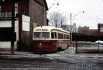
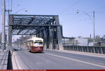
|
ALRV 4205 crosses the bridge over the railway lands. Photo by Rob Hutch. |
Barriers in the South and North
Bathurst Street ended abruptly at Front, with the railway tracks proving to be an effective barrier to southern extensions. Although the Canadian National Exhibition had been sitting in its current site since 1879, most access occurred at Dufferin Loop, or via temporary shuttle cars running along temporary horse-car tracks at Strachan and Wellington. Service to the Exhibition didn’t improve until August 25, 1916, when an old bridge over the Humber River was moved to the foot of Bathurst Street. The bridge was placed on a south-westerly angle (which provided less width of railway to cross) and tracks were extended along it and the edge of old Fort York (the original plan would have put the tracks right through the fort) to the Exhibition.
These tracks were used only when the Exhibition was operating, and the alignment of the bridge provided poor access to the industrial waterfront and the new Maple Leaf Stadium (home of baseball’s International League Toronto Maple Leafs). In 1931, the bridge was moved again, into its current configuration (with another bridge added to span the additional distance) and, on June 22, regular service began on the Fleet Streetcar. The Fleet service was renamed ‘Fort’ within a month.
To the north, the Bathurst Streetcar was blocked by the Canadian Pacific Railway tracks running east and west just north of Dupont Street. Effective July 10, 1894, Bathurst cars were terminating at a wye at Dupont Street. On October 11, 1906, that terminus had been moved a few blocks west on Dupont to a wye at Christie. An underpass was built beneath the CPR tracks on Bathurst in 1914, but it wasn’t until 1921 that Bathurst cars were extended north from Dupont. In 1914, the dispute between the City of Toronto and the Toronto Railway Company about news services was in full force and the city briefly considered serving the area with a Toronto Civic Railway line operating south from St. Clair to Davenport and east on Davenport to Dupont. In the end, the city decided to wait until the TRCs charter expired. Finally, on December 21, 1921, the Toronto Transportation Commission extended Bathurst streetcars north to St Clair, where they looped on street via St. Clair Avenue and Vaughan Road.
The Golden Age of Bathurst
By the mid 1930s, Bathurst was a bustling street. Service along Front may have run during rush hours only, but service on Bathurst was handled by as many as four streetcars. Fort cars operated between Fleet Loop and Wolseley loop, located just north of Queen. Regular Bathurst cars operated from St. Clair to Adelaide and Church via Bathurst and Adelaide. Bathurst Tripper service ran from Keele and St. Clair all the way to Sherbourne and Front, and Bay cars entered service using an unusual ‘swing’ configuration, from St. Clair Carhouse via St. Clair, Bathurst, Dundas, Victoria and Richmond.
The Second World War increased service, with the CNE transformed into a military base. For the duration of the war, Fort cars were extended to Exhibition Loop, as were rush-hour Lansdowne cars, straying off their regular route and running from Lansdowne and St. Clair via Lansdowne, Dundas and Bathurst. At the north end, Vaughan Loop was opened on April 23, 1942, running behind the stores lining the southern sidewalk of St. Clair Avenue, between Bathurst Street and Vaughan Road. This reduced congestion at the Bathurst/St. Clair and St. Clair/Vaughan intersections.

|
|
R. Hill caught this PCC turning from Adelaide south onto Church. Photo donated by Rob Hutch. |
Subway Openings Cause Retraction
When the Yonge Subway opened, streetcar tracks on Front were paved over from York to Scott and the Bathurst Tripper service eliminated. Fort continued to operate, sometimes up to Wolseley Loop, sometimes as far north as St. Clair. Bathurst cars continued to serve Adelaide Street until 6:30 p.m., after which time their southern terminus would shift to the Exhibition and Fort cars would retire for the night.
Bathurst’s last years on Adelaide were complicated by the decision by the City of Toronto to gradually alter Adelaide and Richmond Streets one way only, rendering half the tracks on Richmond and Adelaide useless. On Monday, May 5, 1958, these restrictions forced the TTC to alter the looping of Bathurst cars off of Victoria Street and Richmond Street. Instead, cars operated east on Adelaide to Church, north on Church to Richmond, and west on Richmond to York, operating south on York to turn west on Adelaide. Finally, on Monday, June 13, 1960, the one-way restrictions were extended west to Simcoe Street, making westbound operation on Adelaide between York and Simcoe impossible. Bathurst cars now looped downtown by operating east on Adelaide, south on Church and west on King back to Bathurst.
This change created significant streetcar congestion on King Street between Bathurst and Queen. At the time, King cars were operating at one minute intervals, along with Kingston Road tripper cars operating at ninety second intervals. Adding Bathurst cars operating almost as frequently to the mix, and any delay in service quickly produced backups of streetcars on King, as far as the eye could see. But Bathurst service downtown was on its last legs.
When the Bloor-Danforth subway opened in 1966, the Fort name disappeared, being absorbed into a diminished Bathurst route. Service on Adelaide disappeared and, most disturbingly, the remaining Bathurst streetcar was cut in half, operating only from Bathurst Station, south to the Exhibition. The tracks on Adelaide between Spadina and Bathurst were quickly paved over, although the switches at Bathurst remained as a wye until 1973, when these too were removed.
Switching Carhouses
Cars continued to be serviced at St. Clair carhouse, requiring the use of the tracks north of Bloor, but Vaughan Loop was closed on February 26, 1966 and removed. When the TTC abandoned its streetcar abandonment policy in 1972, Bathurst was the only major north-south route on the system, with its Parliament and Coxwell cousins abandoned in 1966.
When the Spadina Subway opened in 1978, there was hope that service on Bathurst could once again run north to St. Clair. The TTC considered using the underused tracks to bring Bathurst cars to St. Clair West Station. Another plan they considered would have made Bathurst an upside-down ‘L’-shaped route, operating from St. Clair Station, with St. Clair and Earlscourt cars cut back to St. Clair West. Nothing came of this plan, however. Officially, the TTC were concerned that traffic congestion at the Bathurst-St. Clair intersection would cause delays. Looking at the proposal today, it’s clear that extending streetcars at the expense of bus service would inconvenience suburban passengers on the 7 BATHURST Bus wishing to transfer directly to the Bloor Subway. In the meantime, with the closure of St. Clair Carhouse, St. Clair cars make use of the tracks north of Bloor in order to enter and leave service, and they sometimes take passengers along for the ride.
The last major modification to service on Bathurst occurred on April 2, 1973, when the Kingston Road Streetcar was extended from McCaul farther west along Queen and then north on Bathurst to Bathurst Station. Renamed ‘Downtowner’ to promote its new direct-downtown service from the Bloor-Danforth subway, this operation didn’t catch on. By September 4, 1974, it was operating rush-hours only with base service to McCaul loop (except from 1976 to 1978 when base service was routed to Wolseley loop while McCaul loop was rebuilt). All Downtowner service was cut back to McCaul Loop on March 9, 1984, although it retained the name given to it when service was extended. Service on Bathurst may have started up in the shape of an ‘L’, but travel patterns now call for strict north-south operation. Historical remnants of the old services on Bathurst remain in the form of Wolseley Loop, Fleet Loop, and the tracks along Adelaide.
The Future
In June 1995, the Bathurst Streetcar was cut back to Fleet Loop for a year, while the old Exhibition East loop was demolished and replaced by a new Trade Centre at the CNE. In June 16, 1996, the Bathurst cars moved into an expanded, modern loop facility northwest of the old loop, closer to the Exhibition GO Station. In 1998, service was interrupted again as work took place to replace one of the spans on the Bathurst Street bridge, but service resumed a couple of months later.
On July 21, 2000, service began on the new 509 Harbourfront streetcar, sharing tracks from Exhibition loop to Bathurst Street before following a new alignment south on Bathurst and east on Queen’s Quay towards Union station. In September 2007, after a long delay which resulted in a streetcar derailment, the aging tracks on Fleet Street were rebuilt. The construction of Fort York Boulevard allowed the TTC to shut down Fleet Street to most automobile traffic, so that streetcars operate on a private right-of-way from Exhibition loop all the way to Bathurst Street.
The route did see frequent bus substitutions in the years 2017, 2018 and 2019, as delays to the delivery of the Flexity LRVs resulted in a streetcar shortage. Buses operating out of Wilson Garage would replace the streetcars, except during the summer board period when reduced services eased the shortage, and summer traffic from Harbourfront and the Exhibition increased the demand for service.
Plans are on the books to extend streetcar tracks west from Exhibition Loop towards Dufferin Loop and possibly beyond to the Roncesvalles/Queen intersection as part of the Western Waterfront LRT project, although this is not expected to occur before 2020. While this project is not directly related to the Bathurst streetcar, the increase of service to the Exhibition and through the Harbourfront area may make the TTC reconsider its operations in the area, although perhaps the travel patterns connecting the new condominiums near Fleet Street to Bathurst Station are too well-established for Bathurst’s service to the Exhibition to be changed. And while there are no plans to upgrade Bathurst service to LRT operation (the street is too narrow, especially north of Queen), there are plans to rebuild the Bathurst Street bridge over the railway tracks, and this may result in private right-of-way being set up for the Bathurst car south of Front Street to Fleet.
The TTC has invested a lot in the continued operation of the Bathurst Streetcar, and why not? It is one of the most cost-effective routes on the system throughout the year, and late in August it ferries thousands of passengers from the subway to the Canadian National Exhbition. As redevelopment continues south of Fort York, things promise to get more interesting south of the railway lands, and we can expect service on Bathurst to continue for some time.
511 Bathurst Image Archive
|
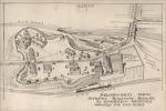
When plans were made to build tracks southwest from the Bathurst/Front intersection to the Exhibition, one of the proposals called for tracks to be run through historic Fort York. The illustrator of this map is unknown. The image comes courtesy the Rob Pineault collection. |
|
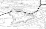
After the managers of the Fort York trust complained about the proposed route, a compromise route was installed along the north edge of the Fort. The image is courtesy the Rob Pineault collection. |
|
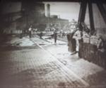
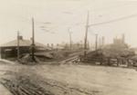
A view of the intersection of Front and Bathurst street under construction circa 1916. Note the triangular angle of the tracks alignment, as the tracks headed southwest, instead of south. this image was taken for the Toronto Archives. |
|
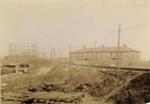
A view of the BATHURST tracks heading towards Fort York. this shot was taken circa 1916 for the Toronto Archives. |
|
A view of the BATHURST tracks following the boundary of Fort York, looking southeast. This photo was taken circa 1916 for the Toronto Archives. |
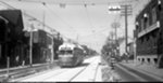
|
Ex-Toronto Railway Company car #170 waits southbound on Frederick south of Front, at the end of its service day on the BATHURST route. This shot, taken circa 1921, is courtesy the Toronto Public Library and Rob Pineault. |
|
At the north end of the BATHURST streetcar line, streetcars and buses connect via Vaughan Loop. Here, on April 24, 1942, bus #705 on the VAUGHAN route meets up with air-electric PCC 4214. Photo donated by Pete Coulman. |
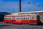
|
The FORT car is an ancestor of today's Bathurst streetcar. At times a shuttle to the Canadian National Exhibition, other times a major augmenter of service up the length of Bathurst, FORT cars trundled into history in 1966, replaced by Bathurst cars which came off Adelaide. In this 1953 scene, TTC A8-class all-electric PCC #4544 prepares to leave Exhibition loop for a short run to Wolseley loop, just north of Queen Street. This photo was donated by Curt Frey. |
|
TTC A8-class all-electric PCC #4511 heads eastbound on Fleet Street, having passed the lighthouse of Fleet Street in FORT service on May 30, 1953. Photo by Richard Glaze. |
|
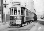
A view of Bathurst Street south on Bathurst Hill approaching Davenport, taken from the front of Peter Witt car #2528, on June 1, 1953. Photo by Richard Glaze. |
|
TTC Peter Witt car #2802 turns from Bathurst westbound onto St. Clair in service on the FORT route on May 30, 1961. The photographer is unknown and the photo is from the Dave Shaw collection. |
|
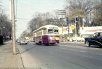
TTC A6-class all-electric PCC #4501 heads southbound on Bathurst, approaching Davenport in this early 1960s shot. The photographer is unknown. |

|
A6-class PCC #4505 turns from Vaughan to southbound Bathurst in service on the BATHURST car. This shot was taken by Robert McMann on March 16, 1963, and the image is courtesy the John Knight collection. |
|
TTC A8-class all-electric PCC #4524 heads northbound on Bathurst past Wellington in this November 23, 1963 shot. Photo by R. McMann, from the John Knight collection. |
|
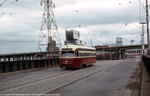
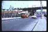
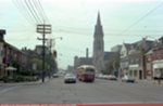
TTC A8-class all-electric PCC #4540 heads north on Bathurst, crossing the Bathurst Street bridge over the railway tracks in this November 23, 1963 shot. Note Maple Leaf Stadium beyond the Gardiner Expressway. Photo by R. McMann, from the John Knight collection. |
|
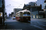
TTC A6-class all-electric PCC #4388 heads eastbound on Adelaide Street, crossing York, in BATHURST service on May 1, 1965. Photo taken by John F. Bromley, courtesy the Hampton Wayt collection. |
|
Chartered TTC air-electric PCC #4044 pays a visit to Wolseley loop, bearing FORT and EXHIBITION WEST ENTRANCE rollsign exposures on February 20, 1966, days before the FORT streetcar would disappear. This image was taken by Robert McMann and is courtesy the Rob Hutchinson collection. |
|
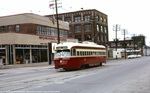
TTC A8-class all-electric PCC #4527 prepares to enter Bathurst station in BATHURST streetcar service. This shot was taken by Richard Glaze circa October 1969. |
|
TTC A8-class all-electric PCC #4528 heads westbound on Fleet Street, crossing Strachan in BATHURST service during the 1970 edition of the Canadian National Exhibition. This photo was taken by Richard Glaze. |
|
In 1971, Joseph Testagrose caught A8-class all-electric PCC #4531 heading north on Bathurst Street towards the bridge over the railway lands south of Front Street. |
|
TTC A8-class all-electric PCC #4543 and another of a similar class prepares to turn from eastbound Fleet Street onto Bathurst in BATHURST streetcar service circa June 1971. Photo by Richard Glaze. |
|
A8-class PCC #4534 heads southbound on Bathurst Street, having passed over the Bathurst Bridge in BATHURST service. This shot was taken circa June 1971 by Richard Glaze. |
|
In this December 1975 shot, W.N.Carr captured A8-class all-electric PCC #4508 resting in Wynchwood Carhouse on service track #7. |
|
TTC A8-class PCC #4514 heads southbound on Bathurst, past construction around Wolesley loop in this October 1976 shot by Richard Glaze. |
|
TTC A8-class all-electric PCC #4533 heads southbound on Bathurst in BATHURST service, approaching Queen. This shot was taken circa October 1976 by Richard Glaze. |
|
TTC A8-class all-electric PCC #4547 heads southbound on Bathurst passing Wolesley Loop in BATHURST service in this October 1976 shot by Richard Glaze. |
|
TTC A8-class all-electric PCC #4521 heads northbound on Bathurst, passing Wolseley Loop in this November 1976 shot by Richard Glaze. |
|
TTC A8-class all-electric PCC #4531 heads westbound on Fleet Street, approaching Garrison Road in BATHURST service in this May 1978 shot by Richard Glaze. |
|
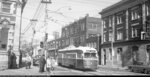
TTC A9-class ex-Cincinnati all-electric PCC #4573 heads northbound on Bathurst, approaching Dundas in BATHURST service, circa August 1978. Photo by Richard Glaze. |
|
TTC A9-class ex-Cincinnati all-electric PCC #4551 heads northbound on Bathurst in BATHURST service, approaching King Street circa September 1978. Photo by Richard Glaze. |
|
TTC A9-class ex-Cincinnati all-electric PCC #4554 heads northbound on Bathurst, approaching Richmond Street West in BATHURST service. This photo was taken September 4, 1978, by Richard Glaze. |

|
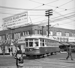
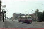
TTC A9-class ex-Cincinnati all-electric PCC #4554 pauses southbound on Bathurst at King in BATHURST service on September 4, 1978. Photo by Richard Glaze. |

|
TTC A9-class ex-Cincinnati all-electric PCC #4560 pauses southbound on Bathurst in BATHURST service at King Street on September 4, 1978. Photo by Richard Glaze. |
|
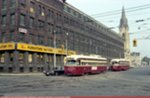
TTC A9-class ex-Cincinnati all-electric PCCs #4569 and 4560 pause southbound on Bathurst at King Street, in BATHURST service on September 4, 1978. Photo by Richard Glaze. |
|
TTC A9-class ex-Cincinnati all-electric PCC #4574 turns from eastbound King onto northbound Bathurst on Labour Day, 1978 in BATHURST service. The car is either entering service, or diverting around the Labour Day parade. This photo was taken by Richard Glaze. |
|
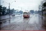
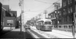
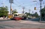
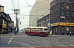
TTC ALRV #4219 crosses Queen Street West, southbound on Bathurst in 511 BATHURST service circa January 1992. This photo was taken by Richard Glaze. |
|
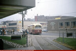
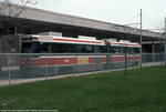
In the mid 1990s, Exhibition loop was closed to allow for the construction of a new trade centre. In 1996, a new, modern facility was opened at the north end of the Exhibition, beneath the Gardiner Expressway, featuring private right-of-way and plenty of storage space to handle CNE crowds. This 1998 photo was taken by James Bow. |
|
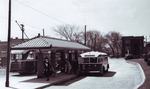
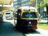
TTC ALRV 4232 picks up passengers at Bathurst station while in service on 511 BATHURST on April 17, 1999. Photo by Jeffrey Kay. |
|
Chartered PCC streetcar #4949 pauses in Bathurst station in the summer of 1999. Photo by James Bow |
|
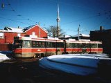
TTC ALRV streetcar #4236 at Wolseley Loop one block north of Queen Street. This 2000 photograph is by Rob Hutchinson. |
|
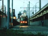
Rob Hutchinson caught this twilight shot of ALRV 4232 in the north side of Exhibition loop, in the year 2000. Exhibition loop wraps around the columns of the Gardiner Expressway. |
|
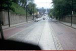
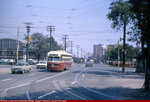
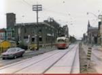
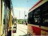
CLRV 4155 travels west on private right-of-way along Fleet Street to the Exhibition. This stretch is the least busy on the 511 Bathurst Route. This photo was taken by Roman Fomin on December 9, 2009. |
|
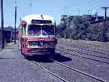
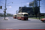
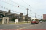
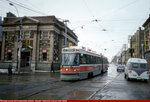
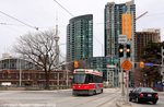
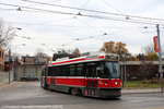
TTC ALRV #4248 leaves Bathurst Station Loop to continue its trip all the way south to the Exhibition. Photo by Roman Fomin on November 14, 2011. |
|
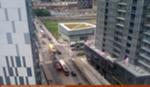
Darwin O'Connor captured this aerial shot of three generations of streetcars (a rebuilt PCC, a CLRV and a Flexity LRV) operating on Bathurst Street, just south of Fort York Boulevard, on July 9, 2017. This shot looks north. |
References
- Bromley, John F., and Jack May Fifty Years of Progressive Transit, Electric Railroaders’ Association, New York (New York), 1978.
- Filey, Mike, The TTC Story: The First Seventy-Five Years, Dundurn Press, Toronto (Ontario) 1996.
- Hood, J. William, Street Railways - Toronto: 1861 to 1930, Maps Project, Toronto (Ontario), 1999.
- Stamp, Robert M., Riding the Radials: Toronto’s Suburban Electric Streetcar Lines, The Boston Mills Press, Erin (Ontario), 1989.
Thanks to Bill Robb, John Bromley and Ray Corley for their corrections to this web page.